Riverains
Exhibition Dates:
Illumini Festival Shoreditch September 2011
Watermans Gallery London June 2013
Originally a site-specific proposal for B.tween Festival Manchester, Riverains Is a multi-user mobile story game, which collaboratively maps an imaginary world onto a cityscape. Riverains are conceived as souls tied to watery energies, running under our cities in rivers, cables, sewers and tunnels. They travel unseen by these invisible routes and cluster around sites of past experience. Participants can use their mobile phone to discover this hidden world, which will correspond to real underground locations aligned with the sites of notable events, and, then use the Riverain’s overheard tales to map those sites and find clues and directions to others.
Riverains was subsequently commissioned for the Illumini Festival in London in 2011 under the theme of ‘Secret Underground London’. A locative trail was created along Old Street and Shoreditch High Street using video poems and empedia software. The artist collaborated with Ximena Alarcon and Kassia Molga to create a combined locative and installed experience using a combination of texting, QR codes on stickers and Layar software.
Manchester and London have a rich underground world of hidden or “lost” rivers, nuclear fallout facilities and command centres and Second World War bunkers, in addition to Victorian sewers and underground railway system. It also has an archeology going back through medieval to Roman times. The Riverains will be drawn from this rich history and from the annals of poverty, industrial revolution, political protest, commerce and innovation, and uncanny happenings. The project maps video sprites and stories across a central London.
The project allows the public, using a combination of website and GPS-enabled mobiles or mobiles with image and QR code recognition, to discover the Riverain presences, which suddenly appear to participating individuals. They will emerge on screen and speak when automatically triggered by pre-tagged locations. Ultimately it is intended that users can also use the Riverain’s tales to discover new sites and find clues and directions to the mysterious Gatekeeper. Once they find the Gatekeeper they will be able to further create and animate their own video avatars which can be determined through a collective web interface. A dark map of the city will be progressively lit by a virtual torch or lantern as the teams or individuals discover the stories and the stories can be stored and replayed by participants.
While a basic terrain and story map will have been placed online in advance, it is intended that the database will be form a growing urban map of user-generated stories. To guard against unwanted spamming an editorial level will be built into the project along the lines of the earlier Starshed project, which mapped tales of the uncanny across a city.
(see: http://www.electricpavilion.org/content/roots/starshed/index.html) and be visually similar to the installation Hosts
Technologies: Most smart phones can now access GPS signals, so we employ a combination of location-based triggering via Empedia, Layar and QR code reading from Posters on the route , related to specific sites

Poster with QR Code and map location


Manchester hidden river map

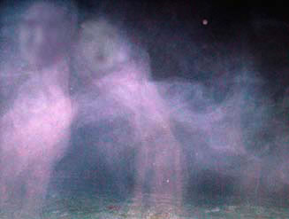
Shoreditch participants with Jackie Calderwood in centre

Ximena Alarcon on right with participants

Early PDA visualisation